
Shipping class: Small Parcel

92 Historic County Tops – Multi Summit Peak Bagging Challenge | Adventure Short-Sleeved Pre-Shrunk Fabric Unisex Cotton T-shirt Active
This t-shirt is the perfect memento for those ready to take on or have completed the ultimate multi-summit challenge of conquering the highest point in the 92 historic counties of the United Kingdom.
Its looser fit and crew neck offers a casual, lightweight feel, along with the right amount of stretch provides a comfortable fit.
Available in small, medium and large, the t-shirt is pre-shrunk fabric and made out of 100% combed ring-spun cotton, while heather colours are 52% combed and ring-spun cotton and 48% polyester.
Colours:
Black
Navy
Forest
Asphalt
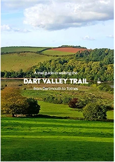
A Trail Guide to Walking the Dart Valley Trail
A helpful and practical pocket guide to walking the long-distance Dart Valley Trail.
The Dart Valley Trail is a walk along one of the most scenic rivers in Devon, the River Dart. The trail begins in Dartmouth Harbour, a town long associated with naval activity and home to the prestigious Britannia Royal Naval College. From here, the path leads along and over the rising hills and wooded banks of the Dart Valley. The variety of landscape provides striking views up and down the valley as well as beyond to Dartmoor National Park. En route, you will pass through the picturesque villages of Dittisham, Tuckenhay, Cornworthy, and Ashprington before finally arriving in Totnes. All these villages provide a different selection of cosy pubs, waterside restaurants, and places to stay.
This Guide contains
- Detailed 1:25 000 OS maps covering the entire route.
- Route broken down into easily manageable legs.
- A suggested kit list, also available for free to download.
- Travel information.
- Places of interest and village amenities such as historic locations, accommodation, eateries, public facilities.
- Full six-figure grid reference for GPS reference.
- Colour photography throughout.
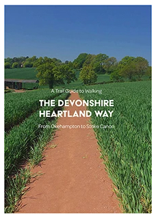
A Trail Guide to Walking the Devonshire Heartland Way
The 43-mile-long Devonshire Heartland Way encompasses areas of the Devonshire countryside rarely visited by most owing to the remoteness of the area. This trail, therefore, offers a great route for those wishing for a more peaceful way to see hidden parts of Devon.
The Devonshire Heartland Way is a recognised trail, waymarked by the Spindle Berry flower. A fitting marker as you are likely to encounter many of the flowers growing in the hedgerows along the route.
You will initially begin in the town of Okehampton, located at Dartmoor’s northern edge and home to an impressive back drop – the rising hills that make up Dartmoor’s northern plateau. The start point can be found before the entrance of the train station. From here, the route heads west to east crisscrossing through the countryside as it winds through numerous, beautiful, picture-postcard hamlets and villages until you arrive at the historic market-town of Crediton.
Leading on from Crediton, for the final stretch of this trail, walkers initially proceeds up and through the Victorian pleasure ground of Shobrooke park before leading onwards through the villages of Newton St Cyres and Brampford Speke before finally arriving at the small settlement of Stoke Canon, located in the Exe Valley.
This Guide contains
- Detailed 1:25 000 OS maps covering the entire route.
- Route broken down into easily manageable legs.
- A suggested kit list, also available for free to download.
- Travel information.
- Places of interest and village amenities such as historic locations, accommodation, eateries, public facilities.
- Full six-figure grid reference for GPS reference.
- Colour photography throughout.
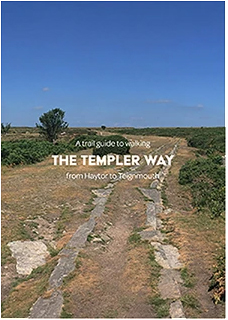
A Trail Guide to Walking the Templer Way
At 18 miles long, the Templer Way follows through some of the most popular areas of Devon. The trail provides a wide array of scenery: from open moorland, meadows, and woodland to the shores of the estuary and coastal beaches.
The Templer Way is a recognised trail waymarked by a wheel, tiller and a barge’s rudder. This waymarker acts as a reference to the fact the route once carried quarried granite from Haytor as it was transported down to the coast. Using a mix of rights-of-way and permissive paths, the Templer Way follows as close to the original route as possible. First, you shall walk along a still visible granite track bed where horse-drawn wagons once pulled carts laden with massive slabs of granite to the beginning of the Stover Canal. The Stover Canal, incidentally, was originally built to transport clay. From here, shipments were then transported onwards to Teignmouth Docks where materials were then shipped onwards to other parts of the country and beyond.
You will start the trail on the eastern edge of Dartmoor at Haytor, one of the more popular spots. It is easy to see why given the large exposed tor that stands prominent in front of you. It provides a truly breath-taking panoramic view of the surrounding area. From here, the trail leads down through Bovey Tracey, famous for its links to pottery, and onto the start of the remains of the Stover Canal. Next, walkers pass through the historic market town of Newton Abbot. From here, the trail leads along the southern shore of the Teign Estuary, offering yet more fantastic views of the northern slopes and shore. You will eventually arrive at the small coastal village of Shaldon. A final trip across the river using a ferry brings you to the finish line at the popular Victorian seaside resort of Teignmouth. Here, you will link up with another long distance trail called the South West Coast Path.
This Guide contains
- Detailed 1:25 000 OS maps covering the entire route.
- Route broken down into easily manageable legs.
- A suggested kit list, also available for free to download.
- Travel information.
- Places of interest and village amenities such as historic locations, accommodation, eateries, public facilities.
- Full six-figure grid reference for GPS reference.
- Colour photography throughout.

A Trail Guide to Walking the Two Counties Way
At 56 miles long, the Two Counties Way is truly a wonderful route that takes in the varied landscapes of Devon and Somerset as well as the marvels of industrial history that forged Britain’s industrial might.
The Two Counties way is not a recognised national trail but rather made up of sections from other long distance national trails, ancient public foot paths, bridle ways and roads. This book was created to act as a guide for walking this wonderful route as it passes through the counties of Somerset and Devon.
You will initially begin in Somerset’s county town of Taunton before embarking on the route the Grand Western Canal, which dates back to the mid-18th century, once forged. Although most of the canal has long disappeared, remnants of the channel and tow path still exist. The final 11 mile walk to Tiverton remains intact and is a designated country park. This stretch offers a peaceful and tranquil escape allowing you to ponder how the canal would have once been a bustling hive of barges transporting cargo to its next destination.
From Tiverton, the path proceeds down and over the high rolling hills of the eastern side of the Exe Valley. At certain points, this part of the trail offers fantastic panoramic views stretching miles across the county. Upon reaching Broadclyst, you will make your way to Exeter’s historic canal basin.
For the final stage of this path, as you leave Exeter’s urban areas, you will be greeted with an array of birdlife as the path follows Exeter’s ship canal towpath onwards through marsh land that has been designated wildlife habitats. You will also bypass the lavish fortified manor and country estate of Powderham Castle before finally arriving at the coastal village of Starcross, near the mouth of the Exe Estuary.
This Guide contains
- Detailed 1:25 000 OS maps covering the entire route.
- Route broken down into easily manageable legs.
- A suggested kit list, also available for free to download
- Travel information.
- Places of interest and village amenities such as historic locations, accommodation, eateries, public facilities.
- Full six-figure grid reference for GPS reference.
- Colour photography throughout.
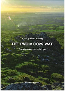
A Trail Guide to Walking the Two Moors Way
The Two Moors Way, roughly 103 miles in length, encompasses some of the most beautiful parts of Devon’s countryside as it cuts down through the centre of Devon and briefly ventures into Somerset. The Two Moors Way offers a truly fantastic experience and provides a great insight into the many aspects of life in Devon and its varied landscape.
Typically, the Two Moors Way trail is walked from south to north, starting at the town of Ivybridge located on Dartmoor’s Southern plateau and finishing on the North Devon coast at Lynmouth.
This book, a Guide to Walking the Two Moors Way, acts as a reference for the full north to south route. You will begin in the picturesque and charming village of Lynmouth. From here, you will leave the towering sea cliffs behind as you venture over the diverse landscape of Exmoor. Next, you shall proceed across open moorland, through ancient farmsteads, and past tiny hamlets – all of which offer a fantastic insight into Devon’s isolated rural life.
Leaving Exmoor, you will merge into the rarely visited rolling hills of mid-Devon. From here, pressing onwards, you will crisscross through a network of country lanes and along narrow hedgerows, bypassing remote historic churches that date back hundreds of years.
For the final stage, you will initially pass through wooded valleys and alongside stone walls and prehistoric bronze age settlements before finally making your way across the barren, lonely, and inhospitable moorland with its scattered granite tors to finally descend into Ivybridge. The finale makes for an impressive ending to this wonderful route.
This Guide contains
- Detailed 1:25 000 OS maps covering the entire route.
- Route broken down into easily manageable legs.
- A suggested kit list, also available for free to download.
- Travel information.
- Places of interest and village amenities such as historic locations, accommodation, eateries, public facilities.
- Full six-figure grid reference for GPS reference.
- Colour photography throughout

Cycling End to End, the Wrong Way: John O’Groats to Land’s End
8 days of torrential rain, battling the prevailing winds, wild camping, solo, self-supported, cycling 80 miles with one leg – all made for one of the hardest challenges I’ve attempted; a true test of mental and physical strength.
Land’s End to John O’Groats is a, renowned and iconic, long-distance cycle ride which traverses the length of mainland Britain. The route traditionally starts in the South West and finishes in the North East, passing through some of the most scenic landscapes in England and Scotland. Every year, hundreds embark on the cycling experience that, no doubt, leaves a lasting impression of an unforgettable experience.
Cycling End to End had been on my mind for some years, after all it is one of the most iconic long-distance rides in the world. The appeal was not only the challenge of travelling such an epic distance under my own steam, but to also see the beautifully diverse landscape throughout the United Kingdom. For logistical reasons, mainly living in Exeter, I decided to complete my journey from top to bottom, going the wrong way; not giving much thought to why everyone goes Land’s End to John O’Groats.
I wanted to take a more scenic route and immerse myself in the whole experience, rather than race to the end. I planned my trip over 18 days, using the national Cycle Network of quiet roads and tracks. With my noble steed (old mountain bike), I set off for John O’Groats to start on a solo, self-supported adventure that would cover the breadth of Britain. My End to End cycle adventure would turn out be one of the hardest tests of mental and physical challenges I’ve endured.
I’ve set out to create this book to provide information on every part of cycling JOGLE /LEJOG should you wish to undertake the challenge. It includes my account of each day giving you a feel for of the experience. Unlike traditional route books, I haven’t included maps, you will find links to resources where you’ll be able to download GPX files or purchase route books.
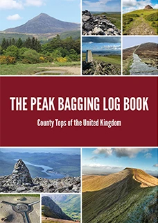
The Peak Bagging Log Book
Take on the ultimate challenge of conquering the highest point in every county.
To help you undertake a challenge like no other, this book provides a fantastic way of keeping a track record of how and when you have reached the highest point in every one of the United Kingdom’s 108 counties. Each county top is listed in order from highest to smallest, providing stats, a short bio, and log to fill in, allowing you to tick off every county top once you have reached each summit.
Encompassing England, Scotland, Wales and Northern Ireland, the hills and mountain tops of the United Kingdom are an assorted bunch. These geographical, highest points range in both height and uniqueness – from the mighty Ben Nevis at 1,345 m, the highest point in Scotland, to the-low lying Holborn Hill in the metropolitan City of London at 22 m above sea level. Conquering each peak provides an incredible adventure and allows you to explore the diverse and beautiful landscapes of the entire United Kingdom.
Get ready to embark on your own adventure and let us be there to help you along the way. Have fun!